Industries Empowered: DFlyit's Aerial Solutions Across Diverse Sectors

Tailored Solutions for Every Sector: Elevating Operations and Insights with DFlyit’s Industry-Specific Aerial Services.
Agriculture

Agriculture

Precision farming, crop monitoring, and pest control.

Transportation

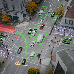
Traffic monitoring, infrastructure inspection, and route optimization.

Traffic Monitoring
Tourism

Tourism

Aerial tours, site inspections, and destination marketing.

Research and Academia

Environmental research, archaeological surveys, and academic studies.

Academia
Inventory

Retail

Inventory management and warehouse monitoring.

Healthcare

Medical supply delivery and remote patient monitoring.

Healthcare
Defence

Defense and Security

Surveillance, reconnaissance, and border patrol.

Surveying and Mapping

GIS mapping, land surveying, and cartography.

Mapping
Delivery

Delivery and Logistics

Last-mile delivery and logistics optimization.

Emergency Services

Search and rescue, disaster response, and firefighting support.

Emergency
Telecommunication

Telecommunications

Tower inspections and maintenance.

Media and Entertainment

Aerial photography, filmmaking, and event coverage.

Film Making
Wild Life

Environmental Conservation

Wildlife monitoring, habitat assessment, and anti-poaching efforts.

Mining

Exploration, site monitoring, and environmental assessments.

Mining
Insurance

Insurance

Property assessment and claims processing.

Infrastructure

Bridge inspections, road surveys, and urban planning.

Infrastructure
Transmission Lines

Energy

Inspection of power lines, pipelines, and renewable energy infrastructure.

Construction

Surveying, site mapping, and project monitoring.

Construction